With Starlink on board we made some radical changes to how we access weather forecasts on long passages and how we stay in touch with the “home front” – our friends and family back home – when miles offshore.
Twenty years ago when we crossed the Atlantic from Europe to Brazil we had an Iridium phone which we used for for downloading weather forecasts and sending a daily SMS message to the home front. It worked well and an Iridium device combined with PredictWind is still a widely used solution to this day. However, as we set off on our crossing from Canary Islands to Brazil two months ago, with fast internet access, we searched for an alternative solution.
Reassuring those at home
One of the problems with having Starlink is that the home front expects you to check in every day, and gets very nervous if you don’t. Telling them beforehand that equipment breaks down or that the boat might move too much for it to catch the satellites, does not really help. To let them know exactly where we were, we used the noforeignland app to record and upload our Atlantic crossing over Starlink. This worked well for us but we wanted a backup in case we couldn’t connect to the internet. A noforeignland article on Zoleo opened our eyes to this product which we added as a back up to post a daily position update and guarantee everyone’s peace of mind.
Accessing weather forecasts when Starlink is off
We leave our Starlink off for 23 hours a day as it devours energy, but wanted a way to have detailed weather reports to hand. It was when reading “Modern Marine Weather” by David Burch that the solution presented itself. Twenty years ago one could download weather forecasts as GRIB files using an SSB radio; something we didn’t do then as we had our Iridium phone. But the product still exists and we realised that we could combine old with new. We could use Starlink connectivity (in stead of the SSB radio) to download custom GRIB weather files on demand from SailDocs – which strangely enough was initially created for the ‘bandwidth-impaired’.
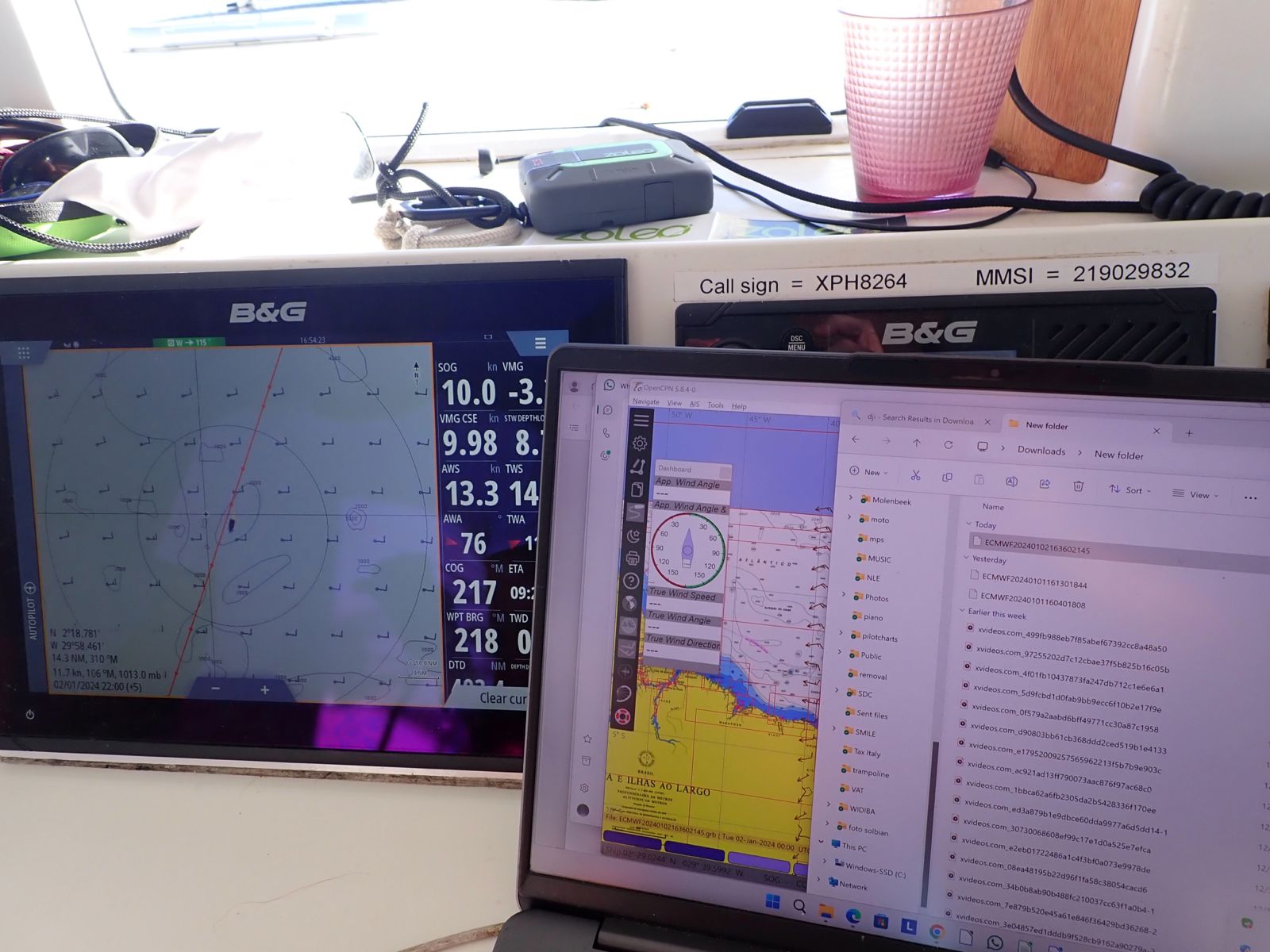
In practice, what did we do?
On passage we would fire up Starlink once a day, email a query to SailDocs, look at Windy (recording our screen while running the different animated forecasts), update our position on noforeignland and then have a quick WhatsApp chat with the home front to let them know all was OK on board.
Downloading custom GRIB files
SailDocs is a free service that works over email – you email them a query, and their service sends a reply with GRIB files attached.
This email to query@saildocs.com requests wind and surface pressure in the ECMWF model for a rectangle 10N to 20S and 40W to 5W with a grid of 0.4 degrees (= 25 NM) every 12 hours for the next 5 days:

There is no doubt that it requires some trial and error to get the format of the query exactly right. But once you have got it, SailDocs automatically delivers any weather information you need directly to your inbox, free of charge.
Viewing the GRIB files
The real work starts when we are off line again with the GRIB files safely downloaded. We copy the GRIB files to both our B&G plotter and OpenCPN on our laptop to overlay the forecasts on our electronic charts.


So now we have three animated weather maps on board: 1) the overlay on the plotter, 2) the GRIBs on the laptop and 3) the Windy screen recordings.
We did try the routing plug-in for the OpenCPN on the laptop but it was too complex for us to master. Fortunately there isn’t much weather routing to do on an equatorial crossing and we still have time to learn before the next passage.
Weather forecasts are the key for a fast, comfortable and safe passage and Starlink allowed us to access weather information in a format made for and by cruisers.
Using this equipment on our 500 hour trip from Gran Canaria to Rio de Janeiro was a bit of an experiment for us. We had never used Starlink, Zoleo or SailDocs before. On the day, the noforeignland app tracking and the SailDocs GRIB files all worked like a charm.
Finally and just to clarify: I have absolutely no affiliation with any of the products mentioned but merely seek to share my thoughts on what we choose for a safe passage.

By Katja Giannini
Katja and Fabio Giannini, a Danish/Italian couple, crossed the Atlantic in 2002-2004 on Faidate, their homebuilt Van de Stadt 47, with their three small children on board. In 2022 they set out again on Faidapiu, a Schionning Arrow 1500 catamaran. In 2023 they cruised the Mediterranean, in 2024 Brazil and they have been in the Caribbean since 2025. Katja put her thoughts about cruising life on paper and it can be downloaded on their website.


Great article – thanks for sharing and glad your passage went well
Thanks Ben! Passage went perfect and we are enjoying Brazil.
Hi Katja,
nice article. We faced the same problem in having home front always expecting news and position but we solved it activating InReach Garmin position every 10 or 20min that are illimited on the monthly base contract.
We are heading towards Brasil, Uruguay the stopping on hard waiting for the austral summer and restart to sail through Magellan strait. What’s your plan?
Alberto s/y Pius HR53
Hello Alberto,
Thank you for your comments! Yes InReach Garming is indeed an alternative to Zoleo but slightly more expensive I believe, since Zoleo doesn’t have a screen but uses your phone (see the article in this magazine).
As far as plans go, while we have a great boat it is not made for the deep South (and neither are we!) so we will be heading back up North after having returned to Europe for the holidays.
Hope to meet you on this side of the ocean and wishing you a good crossing.
Fair Winds,
Katja
I’ve been curious about how Starlink is changing things for cruisers—your point about still using PredictWind with Iridium for years is exactly what I’ve seen too. But I’m really interested in how you handled reassuring folks back home this time vs. the old daily SMS. Did you end up just using WhatsApp or something more creative for that?
On passage we only switch on Starlink once a day for about half an hour for updating weather forecasts. During that time Sailserver (our ‘black box’) uploads track and NMEA data so the folks back home can check online how our day was. In addition, every 12 hours we send our position to two family members through Zoleo (that we purchased following a NFL article) they then forward it to the rest. Last year a friend crossed singlehanded and after 17 days his distressed girlfriend contacted us because she hadn’t heard from him for almost two days. The reason was, we all learned the day after, that he had been enjoying his sail too much so hadn’t thought about switching on Starlink. It confirmed my idea of having fix timed Zoleo position messages, that thing (should!) always work even in bad conditions when your Starlink doesn’t get a fix, is broken or your battery dead. And yes Whatsapp is a dream, that half hour a day when Starlink is on feels like being back home. Fair winds, enjoy you sail!
Did you find the higher power draw of Starlink versus the Iridium phone required any changes to your energy management or charging strategy on the passage? I’m curious
Hi and thanks for your curiosity! Starlink obviously uses much more power than Iridium but we also have much more power (solar) than twenty years ago. Both probably stayed on for 1 hour a day, neither impact the daily power consumption during passage. On passage we limit the usage of Starlink mainly because we switch on ‘Ocean Use’ where we pay per GB. Fair winds!
Great point about how satellite internet has transformed offshore communication. The jump from Iridium SMS updates to real-time connectivity via Starlink must be a game-changer for both weather routing and keeping loved ones reassured back home. I’m curious whether the reliability and latency of Starlink held up during your Atlantic crossing, especially compared to the older Iridium system you’d relied on for two decades.
Hi and thanks for reading! I do not think latency is an issue with Starlink (nor remember this being an issue with our old Iridium). As far as reliability is concerned: our Iridium phone was stored below deck next to the nav table without an external antenna, our Starlink Gen 2 is installed below the front deck. Neither work when the deck is wet, so in the past we took the phone to our monohull cockpit and today we temporarily place Starlink on deck. Although we have a catamaran that doesn’t move much, it does sometime happen that the waves toss us around too much to get a fix. I uploaded a 10min vlog every day on our Atlantic crossing and only once did I have to wait half a day for the waves to calm down. A problem we didn’t have with the Iridium, but at the time vlogs didn’t exist neither.
It’s wild how much things have changed since the Iridium phone days—I remember when sending a single SMS was the big luxury. Now with Starlink you can get fast weather data and actually keep the home front in the loop in real time instead of just one daily check-in. That shift from a one-way reassurance message to constant connectivity must make the psychological side of offshore sailing so different.
So right! It’s a completely other state of mind. Fair winds!