Many Pacific Northwest sailors plan to one day leave the safety of the protected waters, make the Big Left Turn, and head down the West Coast towards warmer climates. We did, too! This article is a personal account of our soutbound voyage.
It took us three years to acquire the right boat and prepare her and ourselves for this big step. We cut the lines that tied us to the docks on Sunday, August 29th, and departed Port Townsend on our journey south. Onboard was me, my wife Olena, and two crew members whom we convinced to join us on this first leg of our trip. This day was a culmination of a long process that included quitting our jobs, selling the house, and moving to the boat in preparation for a new chapter of our lives. We were both excited and anxious about what the future would bring. As we left Port Townsend, the fog encircled us, as if nature wanted to tell us that we literally had to find our own path forward.

The stretch of the coast from Puget Sound to San Francisco Bay is known for harsh conditions, difficult harbor entrances, and cold and foggy weather in the summer. We found all that. We also found new friends, whales and dolphins, beautiful sunsets, and quaint little towns, and we gained an entirely new level of experience. Sailing in the open ocean was a whole new ballgame.
Port Angeles
We departed Port Townsend in the morning and sailed through a dense fog, dodging fishing boats, container ships, and fellow sailors. The situation improved in the afternoon, and we soon reached Port Angeles. We chose to stop there to wait out a day of bad weather in the Straight of Juan de Fuca.
The Port Angeles Boat Haven marina differs from what we were used to in Puget Sound. It is a working marina with a lot of fishing boats and very few pleasure yachts. It is a good place to top up fuel and get some rest. To get to the town it is a long walk, though. We later learned that the city dock next to the ferry terminal would be a more convenient and cheaper choice. We spent a day in Port Angeles, waiting out the worst of the winds, refueled, and departed on the following morning towards Neah Bay. That year, Neah Bay, which is a Native American land, was still closed to visitors due to COVID-19 restrictions. So we could only anchor out but not come ashore. The bay has plenty of room for a lot of boats and offers very good holding. We picked up a spot, and soon, several others joined us, all going in the same direction.

Ocean sailing
The next day, we woke up to a beautiful, sunny morning. We took our time, as our route calculations called for a late departure. Shortly after noon, we picked up the anchor and headed out. An hour later, we started our Big Left Turn – going around the Cape Flattery. It is the furthest northwest point of the continental United States and where the Straight of Juan de Fuca ends and the Pacific Ocean begins.

The first several hours were exciting and encouraging but clearly more challenging than anything else we had dealt with. We were not in Kansas anymore, or more specifically, not in protected inland waters of the Pacific Northwest. The sea state was more than we expected – we had swell from one direction and the building up wind waves from another. The boat moved in a cork-screw fashion. It never felt dangerous, but it was not necessarily comfortable or familiar. It got somewhat worse when the day ended. Night tends to amplify the experience and the emotions. That night, the reality of what we were doing and my responsibility as a skipper started sinking in. On that first night, I could not sleep much. and was tired the next day. My first mate got seasick, and she had to recover. I was very grateful for our crew. Both of them held up very well.
We had to learn some new sailing techniques to improve the comfort of our journey. First, how to pull out the genoa on a pole to keep it from collapsing as the boat moved through the swell. Second, how to reef while sailing downwind. And then how to adjust the sails to keep the boat’s rolling motion minimal. All this was part of a steep learning curve of how to sail in the open ocean.
After two days of rolling in a washing-machine sea, we gybed and turned towards Newport. It was part of our strategy of short hops along the coast. We were all looking forward to getting a few days of rest in a port.

The strategy, weather, and geography
There are two main approaches for traversing this coast. One is to go far offshore, 50-100 nm, covering the entire coast in 5-7 days of nonstop passage. This option minimizes the risk of running into fishing boat traffic close to the shore, encountering fog, and the dangers of entering and leaving the harbors. But it is harder to avoid unforeseen weather and is better to do with crew with offshore sailing experience. We chose the second option, which was to take shorter hops and stop in some ports along the way. That was mainly dictated by our experience or, rather, the lack of it. We wanted to play it safe and be able to avoid the worst weather if needed.
As it turned out, we could not just arrive at a port, take one or two days of rest, and then go to sea again. The ports on the Western coast are usually located on river estuaries. Those rivers bring out sediment and create entrance bars, which, when combined with high winds and large swell, can create dangerous crossing conditions. The best tactic is to approach at the entrance at high water, on the tail end of the flooding tide so the water flows with the waves and wind, minimizing the chance for large standing waves. Once in, we often had to wait for not only the right weather for the next passage leg but also the right sea state and the right time of the tide to exit a bay. All those conditions combined usually turned a desired 2-day stay into a 4- or 5-day wait.
The Pacific High defines the weather in the North Pacific at this time of year, a high-pressure system that usually is parked well offshore and creates northerly and north-westerly winds along the coast. Those winds can get strong and further accelerate by interaction with the land masses when closer to shore.
The two major land masses sticking out to the ocean are well known – Cape Blanco and Cape Mendocino. The winds in their vicinity can be double of what is forecast. They need to be respected.
The high pressure is sometimes interrupted by low-pressure systems that create southerly winds. We did not want those either. We ended up waiting for a low-pressure system to create an interruption in the high-wind-and-big-waves pattern from the high pressure, let it go through, and depart just after it had passed when the high pressure starts building again but does not yet have a chance to intensify. As you may guess, that pattern does not happen on the exact day you think you are ready to leave port.
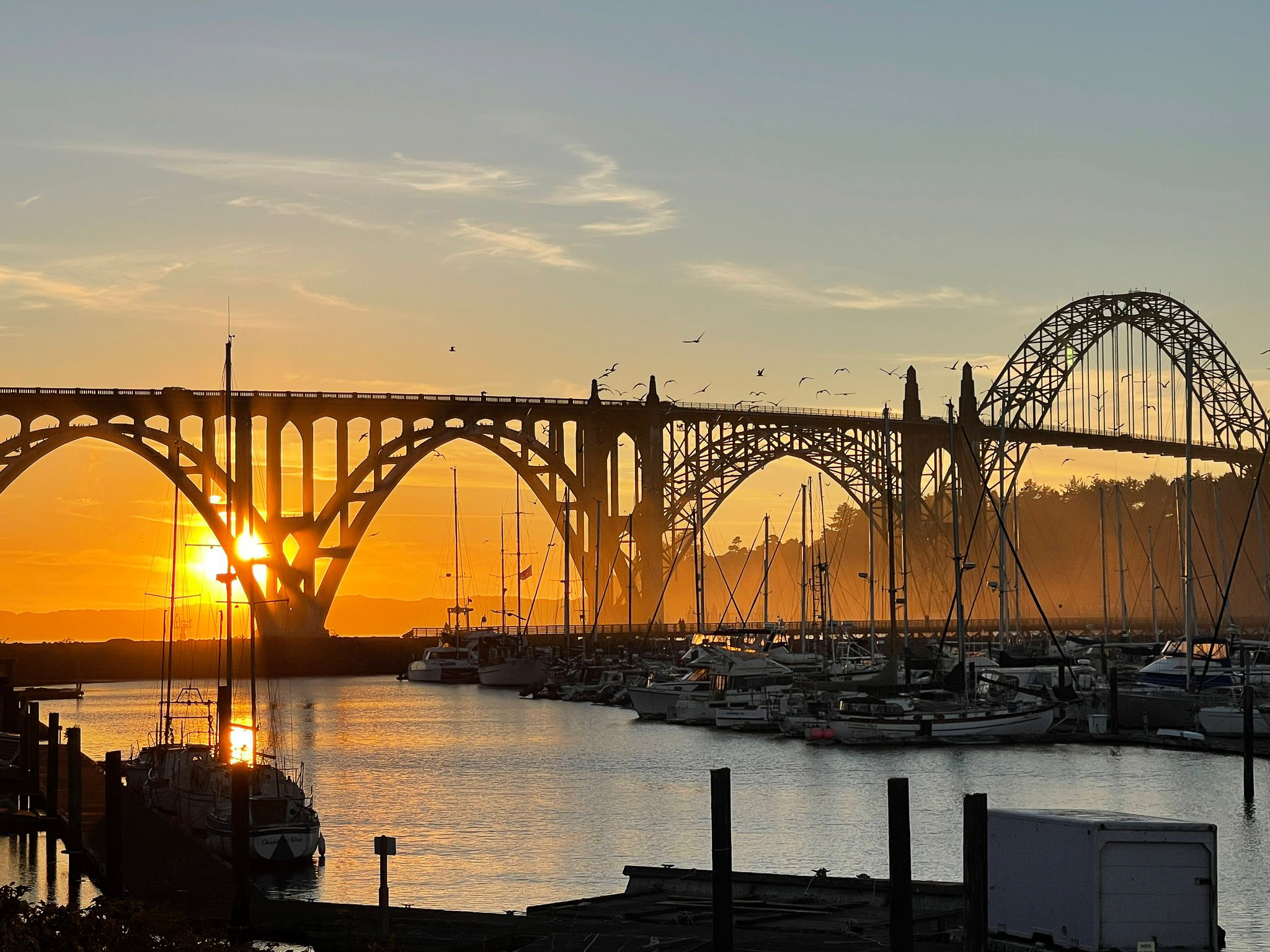
Newport
We entered Newport at sunrise with no fog. Newport is an important port on the Oregon coast. It is a convenient place to stop as the bar crossing is relatively easy compared to other harbors north and south of it. Fishing is a significant industry in Newport, and we encountered many fishing boats entering, leaving, and moving inside the harbor. As we entered the river, a huge bridge greeted us. There was no need to worry about the mast height, as the bridge clearance is 160 feet. It connects the south shore, where the marina is, to the north shore, the location of the central part of the town. On the south side, Newport Marina and RV Park is the place to stop. Just watch the depths entering, as there are a few shallow spots. The guest dock is a long linear one located opposite the fuel dock, and it is the first set of docks in the marina. It is OK to pull into the guest dock if there is space and then register at the marina office. There are a couple of restaurants around the marina, the most notable being the Roque Brewery – great beers and pub food.

The south side of town is where the main tourist attractions are, all conveniently located along the waterfront street. Towards the boardwalk’s end is a well-stocked chandlery – Englund Marine. The best way to get from the marina to town is by bus, which departs once an hour and stops at various places. The marina’s office has a map, the bus schedule, and free tickets.
After four days of waiting, we finally had a weather window to depart. We left early in the morning to leave the river bar at slack tide. Once we were further at sea, we had our first encounter with whales. A large pod of humpbacks surrounded us. We slowed down to minimal speed and let them pass. The whales were swimming around us in all directions, crossing our bow and moving behind. It was quite an extraordinary experience.

Crescent City
We had enough good weather to go around Cape Blanco and arrive in Crescent City, CA, but not enough to go all the way around the next obstacle – Cape Mendocino. Crescent City has a new, completely renovated marina after a tsunami destroyed the previous one. There is an excellent informative display about that event. Crescent City is the only marina on that part of the coast without a bar entrance, so it is a convenient place to stop.
However, the town is a long walk from the docks, and it did not impress us. After a day, we elected to move closer to Cape Mendocino – to Eureka. We wanted to be able to go around the cape with the smallest available weather window. It took us a whole day of motoring in super-dense fog with no wind. We could not tell where the water ends and the sky begins, and we only knew where we were from our GPS and instruments. We entered the Eureka’s river channel with the help of the radar.
Eureka
Eureka is a historic town located several miles down the channels of Humboldt Bay. The entrance to the Bay is over a bar, which is trickier than Newport. The currents in the entrance are substantial and need to be accounted for. The entrance has navigational ranges to help one stay on the right course. It is also advised to call the Coast Guard on Channel 16 to ask about the conditions at the entrance. After entering the Bay and turning left towards Eureka, the current calms down, and it is easy motoring to the docks.
There are two marinas – the Eureka Public Marina on the south side of the channel and a private Woodley Island Marina across from the town. The public marina has reasonable docks and a very helpful harbormaster. It is about a mile from town, but it is possible to get there on foot. An excellent co-op grocery store is about a 10-minute walk from the marina, and there are numerous walking trails leading around Humboldt Bay. From what I know about the private marina on Woodley Island, it is a nicer one, but the main disadvantage is that a highway bridge separates it from the town, and unless you have a car, it is pretty hard to get to Eureka from it.
In Eureka, our relative luck in getting the right weather at the right time ran out, and we had to stay there for over a week. Luckily, we had the company of four other cruising boats, some of which we met in Newport and some new ones. That company made a big difference in keeping our spirits high. We killed the wait time as we could. We visited Carson Mansion, which is said to be an inspiration for a clock tower in Disneyland. We went to Eureka’s Zoo – possibly the smallest zoo we have been to. The zoo’s highlight is the Canopy Walk – a set of hanging bridges connecting a grove of sequoia trees growing inside the zoo. The sequoias, or redwoods, are the main attraction around Eureka. On one of the days, we rented a car and drove through Redwoods National Park, where we took a few hikes. One led us through the old forest with many majestic trees.


The other hike took us to the seashore, where we enjoyed a few hours on a beautiful beach in full sun and with no fog. That day trip was a highlight of our stay.
The last leg
Finally, a day came to leave Eureka. We had our window, but it was small, and we had to move fast to escape a coming low-pressure system with accompanying strong south winds. There was an exodus from Eureka public marina – four boats leaving one after the other, all moving through the Humboldt Bay as though on a parade. We accompanied each other for a bit, but with different boat speeds, we started moving apart and soon lost sight of each other. We sailed for a while, but the wind died, and we switched to motoring. So far, our experience has been a lot like that – either too much wind or too little.

We motored around the infamous Cape Mendocino without problems. We had enough speed to escape the worst of the low-pressure system and ended up with just 10 to 15 knots of wind on the nose. It was tiresome but not difficult. We made good progress, but it was clear that we would not arrive in San Francisco before night, so we pulled into Drakes Bay and anchored. It is a vast bay, appearing open to the sea but calm and protected and with good holding. We had a peaceful night and some well-needed rest.
Passing under the Golden Gate bridge
The following day, we lifted anchor with the sunrise and headed towards San Franciso Bay. It was a glorious morning. All the rain and clouds we had in prior days moved away, and we had a clear blue sky and a beautiful sunrise. It was as if nature understood how tired we were of all the foggy, cold, and overall miserable weather she had sent our way in prior weeks. We were all excited to pass under the Golden Gate Bridge.


As we pulled into San Fransisco Bay, it was a shock to see all the traffic – ferries, tugs, big ships, and small and big sailboats just enjoying their Sunday morning sail. People in t-shirts, enjoying the sunshine and a nice breeze, stared at us, still bundled up in foul-weather clothes. After seeing only fishing boats and occasional sailboats for weeks, this was a sight to behold. We arrived and docked at Schoonmaker Point Marina, a beautiful place that greeted us with the sun, a sandy beach, and palm trees.

It is one of those days we will remember for the rest of our lives. It felt so good to get here, knowing our journey would become easier from this point on.

By Maciek Sarnowicz
Maciek and Olena have been sailing together in Pacific Northwest, up and down Washington and British Columbia, since 2009. In 2021 they left their land life and jobs, sold their house, and embarked on a southbound journey to Mexico and Central America onboard their Outbound 46 - Qué Vendrá.


Hi. What a great blog and personal account of your trip. It felt like I was on board with you. British Columbia is on our bucket list so we will have to do this trip in reverse. Thanks for all the detailed information. Lin, Velvet Lady
Hello Lin,
Thank you. I am glad you like the article. The Pacific Northwest, in general, and British Columbia specifically, is indeed a special place to cruise. I hope you can experience it firsthand!
Maciek, s/v Qué vendrá