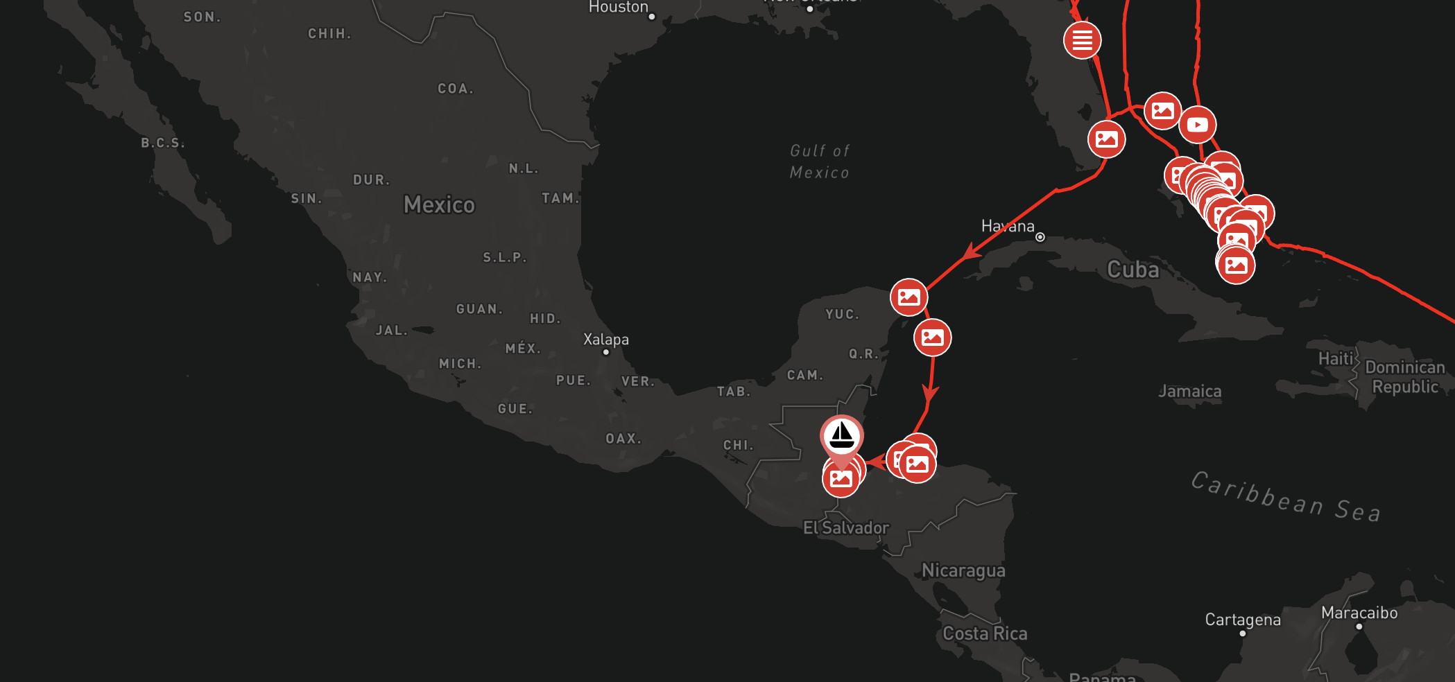
Something we get asked a lot is whether it is possible to display your boat’s journey from before joining noforeignland. The answer is yes, and in this article we will explain how.
Before we get started, it is important to understand how your journey is drawn on noforeignland.
What is a position fix?
Your journey is drawn by connecting a series of position fixes on the map. A position fix is simply a record of a location (latitude and longitude), and when you were at this location (date and time).
When you track your boat on noforeignland, fixes are submitted and saved for your boat. When you show your journey, the fixes are are sorted by date & time, and then joined together using straight red lines with arrows on them which show the direction of travel. The grey dots you see when zoomed in on your journey represent the fixes.
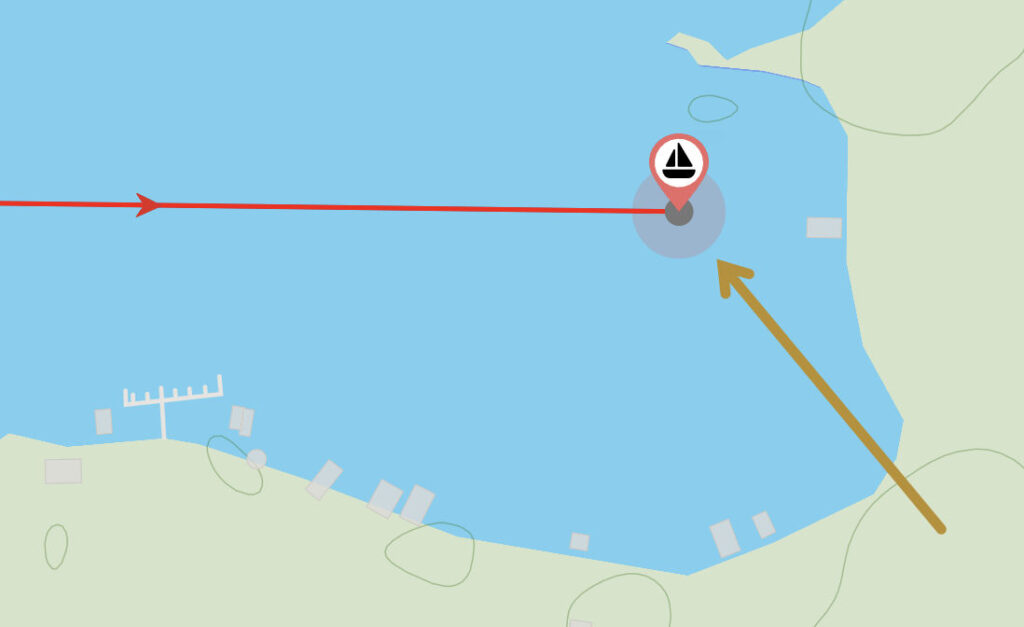
If at any time you add a fix by mistake, you can easily delete it by tapping on this grey dot and choosing the Delete fix menu option. If you are unhappy with the shape of your boat’s track (maybe a straight line connecting two fixes crosses land somewhere), then take a look at our recent article on how to edit the shape of your boat’s track.
There are three ways to add historic fixes to your track:
- Manually add position fixes (can be time consuming).
- Import your track from another tracking website (e.g. PredictWind).
- Import a previously recorded track from tracking software:
- Most chart plotters
- Navionics Boating app
- OpenCPN
- AquaMaps
- More…
Important: Our advanced boat tracking features are only available on our website so you must sign in there in order to proceed. If you normally use our app, then be sure you sign in to our website using the same account by selecting the same authentication method you use with the app (ie. Google, Facebook or Email & Password).
Let’s now look at these three methods in more detail:
1. Manually add position fixes
If you have your log book to hand, and are happy to spend a couple of hours entering fixes from it, then grab yourself a pot of coffee, find a comfortable seat, and carefully follow the instructions in this section. If you have recorded your boat tracks on a chart plotter or other app, and want to import them directly into noforeignland, then skip ahead to section 2.
With your position fix details to hand, sign in to our website and do the following:
- Open your boat page.
- Tap the MOVE BOAT button.
- Drag the map to move the green pin to the location of your fix, then tap the CONFIRM BOAT POSITION button.
- On the next screen enter the date & time for your fix.
- Save your fix by tapping on the ADD FIX button.
Here you can see the green position pin and the date & time entry fields:
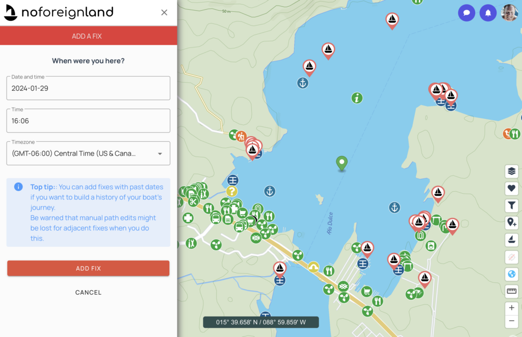
Now, when anyone shows your boat’s journey, your new fix will be included. If you entered a wrong time or position, don’t panic and remember: you can always tap on the fix’s grey dot to delete it and try again.
Top tip: to help accurately position your fix, tap the globe button on the bottom right side of the map to display the latitude and longitude. If your logbook times were not recorded in the UTC/GMT time zone, you should correct the time difference by selecting the correct zone in the date & time entry form.
2. Import from another website
For Farkwar imports, follow the instructions on this help page.
To import a track from PredictWind, follow these steps:
- To avoid adding duplicate fixes and making a mess of your track, you should delete all position fixes on noforeignland for the period of the track you are about to import from PredictWind.
- Then on the noforeignland website:
- open your boat page,
- tap on Settings,
- then choose PredictWind import,
- paste your PredictWind tracking page URL in the form,
- and tap on the UPLOAD button.
- That’s it. You can now go back to your boat page and tap the Show journey to check your track was imported successfully.
3. Import a previously recorded track from tracking software
If you have recorded your track on a plotter or some other app, then there’s a good chance you can import it into noforeignland. As long as the app allows you to export your track to GPX format, it should work. A complete list of supported GPX devices is listed on this help page. If you don’t see your device in this list, then let us know and we will help you get it working.
Important: a GPX file contains either waypoints, routes or a track. Make sure the GPX file you generate contains a track. If you send us a GPX file that contains waypoints or a route, it cannot be added to your journey.
In the next sections we discuss what you need to do to configure your noforeignland account, and how to import a GPX track for your boat:
Configure your noforeignland account
You submit a GPX track file to noforeignland by email. In order for our server to know which boat to add the track to, you must configure your noforeignland account with the email address you will be mailing the GPX file from.
- Sign in to the noforeignland.com website.
- Tap your profile photo at the top-right corner of the screen and then tap on the Settings link.
- Choose the Boat tracking menu item.
- Choose the GPX Imports menu item.
- In the next page, enter the email address you will send your GPX files from.
- Click the SAVE SETTINGS button to save your changes.
Important: your email address is case sensitive, so make sure you enter it here correctly. If you are not sure, then send yourself an email and check which characters are upper case and which are lower.
Generate and submit a GPX track file
I will use Navionics Boating on an iPad to demonstrate how to submit a GPX track, but the steps will be similar for other tracking software. Your app’s help pages should explain what you need to do to generate a GPX track file.
It is very easy to share a GPX track from the Navionics Boating app:
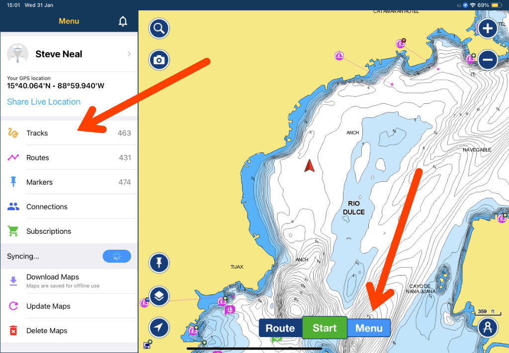
- Open Navionics Boating and tap the Menu button at the bottom of the screen.
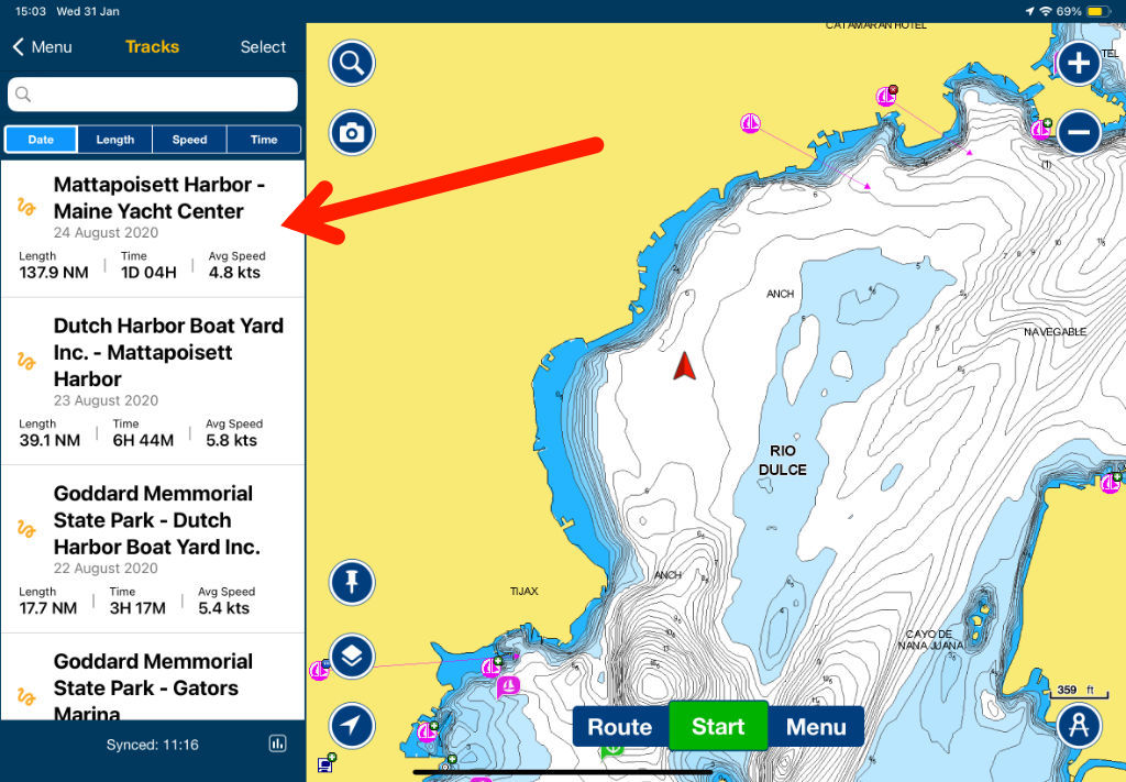
- Select the Tracks menu item.
- Scroll through your tracks and tap to open the one you want to share.
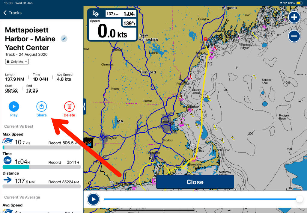
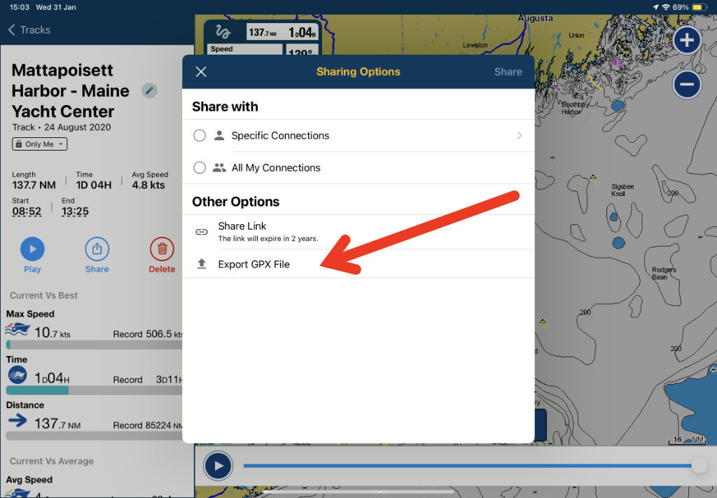
- Once you have opened the track, tap on the Share button.
- Choose the option: Export GPX file.
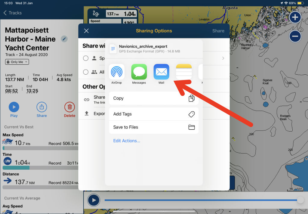
- Select the option share via email to attach the GPX file to an email.
- Send the email (from the address you configured above) to tracking@noforeignland.com.
The following images illustrate how we used these steps to share our overnight passage from Boston to Maine back in August 2020:
Wait for a response email
Our servers usually process GPX emails within a few minutes, and will send a reply to your email address when processing is completed. If everything goes well, you will receive an email letting you know that the track has been added. You can then reload your Boat Journey on noforeignland to see the new position fix, along with a nice detailed track leading up to it:
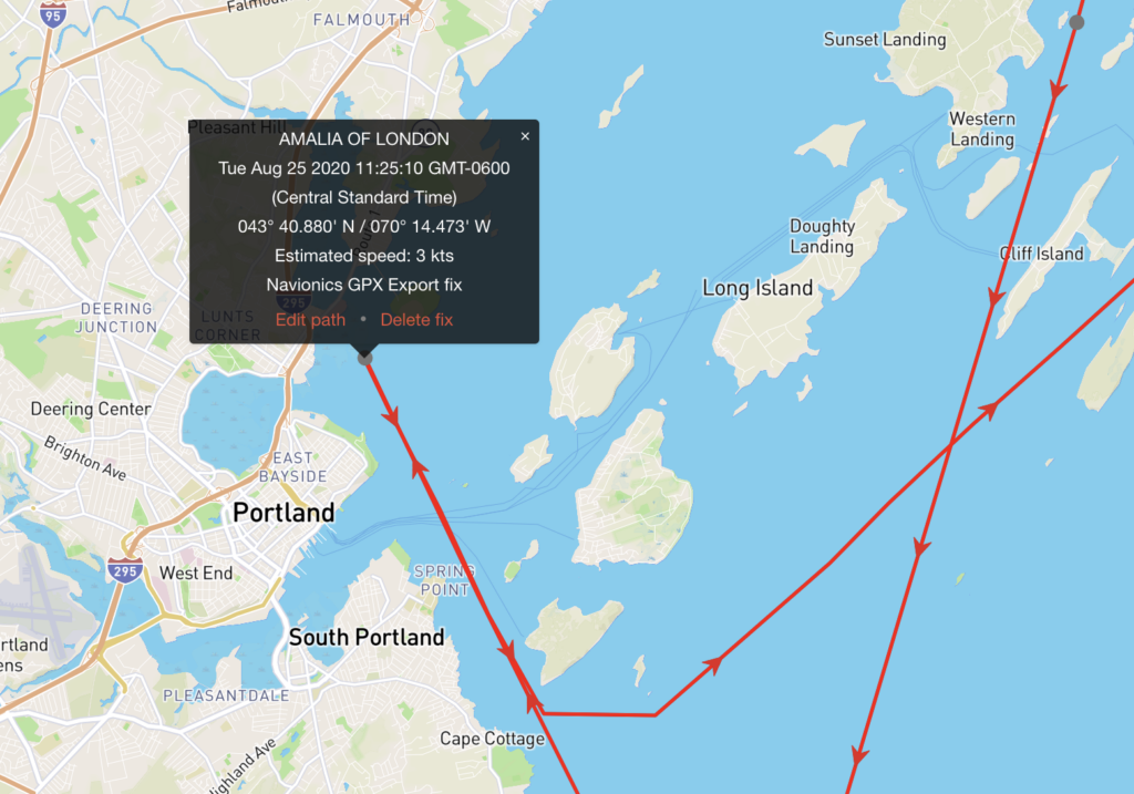
Note that unlike manually entering position fixes, importing a GPX track does not draw straight lines between fixes, but uses the GPS data to draw a very accurate red line on the map.
Top tip: If the import does not work, you will get an error response from our server. Read the response email carefully. The most likely cause of errors is from mistyped email addresses in your GPX Tracking settings on our website. Another common mistake is sending a GPX route, not a track. Run through the above steps again and double-check everything is as it should be.
Do not worry if you email the same GPX track twice, it will not be added a second time.
What if I don’t get a response email?
Our server will always send a reply (either with a success or error message). If you do not get a reply within an hour, then something has gone wrong. In our experience this will be either: 1) you sent the email to a wrong address, or more commonly 2) the email has not been sent yet and is waiting in your mail outbox. Please check that the email has being sent before reaching out to us. You can easily check this by adding yourself to the CC field when sending a GPX file. If it reaches your inbox and the GPX attachment is there, then you know it was sent.
Can I use GPX exports to track my boat in the future?
Yes you can. Before we built the noforeignland app, we did this all the time. Whenever we started a passage we would record the track on Navionics Boating. Then, when we arrived we emailed the track to noforeignland which would update our current location and add a nice GPS path to our journey.
Handling large GPX files
Very long passages can produce very large GPX files. If the file you are trying to submit is too large, it will be rejected by our mail server. In such cases you can compress the GPX data before sending.
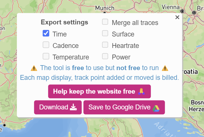
We have heard good things about GPX Studio, a free website that compresses GPX files. Beware that their default compression removes date & time information, making it impossible for us to add it to the correct point in your journey. If you use GPX Studio, then update their export settings to include time information:
Problems exporting GPX from Raymarine plotters
GPX is a messy format. Some software, including Raymarine plotters, choose not to include the all-important time information in their GPX exports, making it impossible to know where they should be added to your journey. If you are confident enough to make some small manual edits to your GPX file before emailing it to us, then this workaround in our help pages explains how to manually enter a date in a GPX file.
Conclusion
We have tried to make it as easy as possible to build a track that shows your entire journey, not just the miles you travelled after joining noforeignland. If you have recorded your tracks and can export them as GPX files, then you can email them to noforeignland and build a very accurate history of your travels. If you have used PredictWind of Farkwar to record your journey you can import it very easily too. If you do not have recorded tracks, it is still possible to manually enter historic fixes (and manually edit the shape of your boat’s track) for your journey.

